Connemara Map: The Best Way to Navigate Ireland’s Wild West
Overview of Connemara, Ireland
Connemara is one of those places that feels bigger than the map it sits on. Out on the western edge of County Galway, you’ll find a region of rugged coastlines, glassy lakes, low stone walls, winding roads and mountains that appear and disappear with the weather. It’s dramatic. It’s atmospheric. It’s chock full of character, and whether you’re planning to hike, drive or paddle your way through it, having a decent Connemara map at hand will make the experience a whole lot easier.
Understanding the Geography
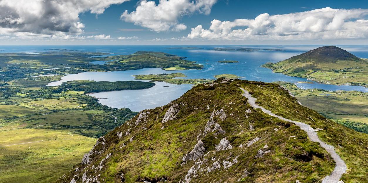
onnemara doesn’t follow tidy lines or predictable shapes. It sprawls and folds around itself, from the Atlantic shores and offshore islands to the peaks of the Twelve Bens and the Maumturk range inland. You’ll pass through Gaeltacht villages like Carraroe and Lettermore, then emerge beside vast boglands or find yourself suddenly climbing into the hills above Leenane. Roads curve to avoid loughs, bypass mountains, or occasionally run out entirely. So it’s worth studying a Connemara Ireland map before you head out. Not just to find your way, but to understand the lay of the land you’re about to wander into.
Driving and Hiking Routes in Connemara
Connemara is a joy to explore by car, if you don’t mind stopping regularly to let a sheep cross the road. The Sky Road loop from Clifden is a great place to start — just a short drive, but packed with dramatic scenery and ideal for a slow cruise. For something a bit longer, head from Roundstone up to Ballynahinch and over towards Recess, where the road cuts through a valley with mountains on either side and bogland stretching far into the distance.
If you’re on foot, Diamond Hill in Connemara National Park is well-marked, manageable, and gives you big rewards for a relatively short hike. Over near Clifden Castle, you can walk the path from Beach Road down past the castle ruins, and continue on along the headland for sea views and scattered farmsteads before looping back to town. In quieter corners like Renvyle or Ballinakill, there are small country lanes and informal walking trails that are ideal if you prefer to explore without a fixed plan — though again, a Connemara map will help you get back to where you started.
For more, check out our dedicated blog on the Best Walks in Connemara.
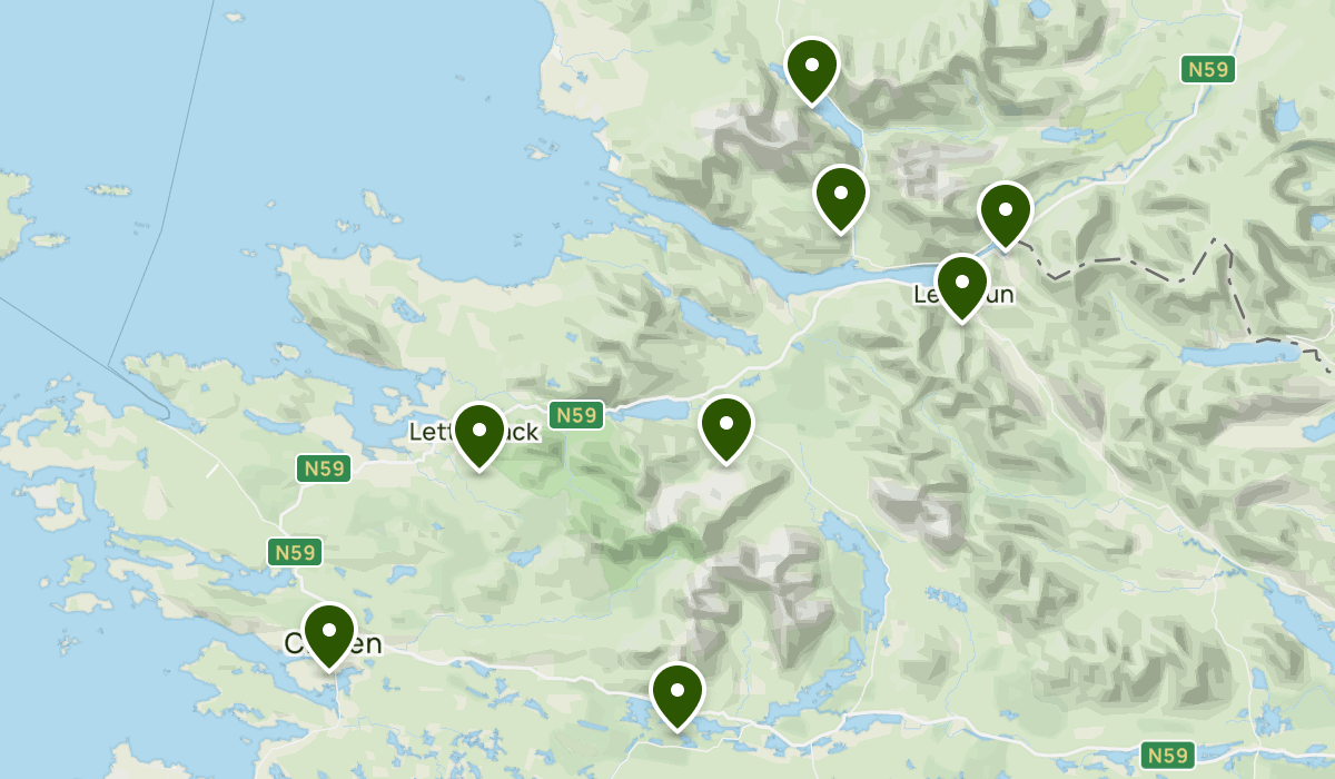
Key Places to Locate on the Map
Clifden stands out immediately as the largest town in the region and a great base for exploring Connemara. It’s where you’ll find plenty of cafes, pubs, shops and galleries, not to mention access to the famous Sky Road, which loops west for jaw-dropping views over the Atlantic and surrounding headlands.
North of Clifden lies Letterfrack, the gateway to Connemara National Park and the starting point for walks up Diamond Hill. Follow the coastal line and you’ll reach Roundstone, a picturesque harbour village known for its charm, craft shops and traditional boatbuilding.
The beaches of Mannin Bay stretch out near Ballyconneely, offering brilliant swimming spots and quiet sandy inlets. Further up, the road leads to Leenane on the edge of Killary Harbour (one of Ireland’s only true fjords) which is framed by dramatic peaks on either side.
To the east, Carraroe and Spiddal mark the heart of the Gaeltacht, where the Irish language lives and thrives. These coastal villages offer great places to stop for fresh seafood, seaweed walks and cultural experiences, with a string of beaches and coves dotting the shoreline.
All of these locations and plenty more are easy to trace and plot on a good map of Connemara. This way, you’ll be able to plan a route that fits your pace and priorities, whether you’re driving, walking or simply exploring the road as it comes.
Best Maps and Resources to Use
Most people rely on digital maps these days, and rightly so. Google Maps works well across most of Connemara, especially around larger towns like Clifden, Roundstone or Spiddal. Waze is great for live traffic updates (though you won’t get many tailbacks between Ballyconneely and Moyard), and Here WeGo and ViaMichelin are solid offline alternatives if you want to download routes ahead of time.
That said, GPS isn’t always foolproof out here. You’ll likely lose signal in the valleys around Kylemore or on the smaller coastal routes, or perhaps you’re worried about your phone bill from constantly using your data while roaming. So if you like a bit of backup, or just prefer something you can actually fold and scribble on, a physical map is always handy to keep in the glove box. The Collins Handy Road Atlas Ireland or the OSI Road Atlas Ireland are two fantastic options that will never let you down.
Where to Stay in the Area
When it comes to accommodation, Connemara has something for every kind of trip. You’ll find everything from remote cottages with mountain views to stylish townhouses in the centre of town.
In Ballyconneely, Flaherty Cottage is a lovingly restored family cottage just a short stroll from the long white sands of Mannin Bay, ideal for anyone who wants peace and proximity to the sea. Also nearby is Diamond Cottage, a luxurious, modern home that balances quiet seclusion with easy access to both Ballyconneely and Clifden.
Clifden itself is home to places like Pink Blossom Townhouse and 17 Canons Lane, both modern, comfortable bases within walking distance of restaurants and pubs. And just outside Clifden, you’ll find larger properties like Ballinakill Lodge in Moyard. It’s perfect for bigger groups, with landscaped gardens and room to spread out.
Further north, Killary Vista in Renvyle offers elevated views over the Atlantic and the mountains beyond, while Lough Fee Cottage nearby is ideal if you’re after lakeside solitude. For something more central on the Gaeltacht side of Connemara, Carraroe Apartment and Spiddal Cottage both offer great access to the coast and easy routes for touring westward.
No matter where you land on the Connemara map, Connemara Holiday Lettings has a place to suit.
Start Exploring Connemara with the Right Map
Having a proper Connemara map isn’t just about getting from A to B. It’s about knowing what you might stumble across on the way, and how to take the scenic route rather than the straight line. Whether you’re zooming in on Google Maps or unfolding a battered road atlas in the passenger seat, take a bit of time to get your bearings.
And when the road finally winds you in for the night, Connemara Holiday Lettings is here to help you find the perfect spot to rest. Browse our full range of accommodation across the region and start planning the kind of holiday where the journey is just as good as the destination.